Property Record
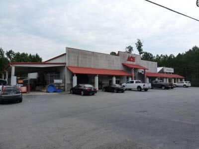
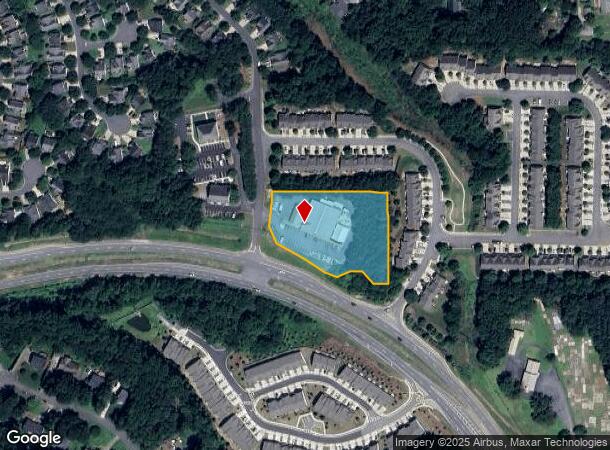
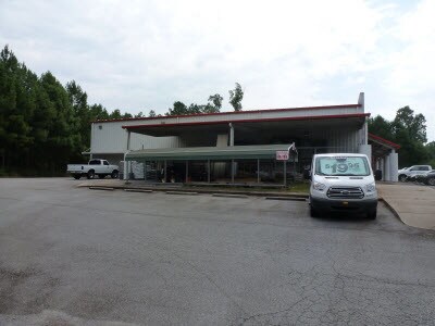
115 Colony Center Dr, Woodstock, GA 30188

NEARBY LISTINGS FOR SALE OR LEASE
Property Detail
115 Colony Center Dr
015N30-00000-092-00B-0000
LL 1257 15TH D
Commercialnec
Cherokee
X
Georgia
13057C0358E
1257
2025
2.11 AC
2025
Cherokee/Woodstock
090906
Atlanta
21,260 SF
Atlanta-Sandy Springs-Roswell, GA
DEMOGRAPHICS near 115 Colony Center Dr
1 Mile
3 Mile
5 Mile
2024 Total Population
5,657
52,788
142,748
2029 Population
6,258
56,438
150,695
Pop Growth 2024-2029
+ 10.62%
+ 6.91%
+ 5.57%
Average Age
42
41
41
2024 Total Households
2,152
18,692
50,536
HH Growth 2024-2029
+ 11.01%
+ 7.37%
+ 5.88%
Median Household Inc
$99,860
$135,166
$131,623
Avg Household Size
2.60
2.80
2.80
2024 Avg HH Vehicles
2.00
2.00
2.00
Median Home Value
$438,636
$433,904
$434,756
Median Year Built
1992
1991
1989
Nearby Places
Map Layers
Map Styles
 Street
 Aerial
- Restaurants
- Banks
- Shops
- Fitness
- Groceries
SALE & LEASE HISTORY
LISTING DATE
SALE/LEASE

Dec 09, 2019
For Sale
Aug 12, 2019
For Sale
Nearby Properties
Address
Land Use
TOTAL SIZE
Lot Size
Zoning
Address
Land Use
TOTAL SIZE
Lot Size
Zoning
330,192 SF
20.40 AC
GC
Address
Land Use
TOTAL SIZE
Lot Size
Zoning
179,182 SF
15.06 AC
OI
Address
Land Use
TOTAL SIZE
Lot Size
Zoning
134,017 SF
31.50 AC
R-40
Address
Land Use
TOTAL SIZE
Lot Size
Zoning
95,478 SF
3 AC
Address
Land Use
TOTAL SIZE
Lot Size
Zoning
186,090 SF
30.08 AC
GC
Address
Land Use
TOTAL SIZE
Lot Size
Zoning
158,427 SF
11.17 AC
GC
Address
Land Use
TOTAL SIZE
Lot Size
Zoning
25.40 AC
E1
Address
Land Use
TOTAL SIZE
Lot Size
Zoning
50,375 SF
5.77 AC
R-80
Address
Land Use
TOTAL SIZE
Lot Size
Zoning
100,696 SF
9.96 AC
E2
Address
Land Use
TOTAL SIZE
Lot Size
Zoning
82,005 SF
15.82 AC
E1
Address
Land Use
TOTAL SIZE
Lot Size
Zoning
121,240 SF
21.04 AC
R1C
Address
Land Use
TOTAL SIZE
Lot Size
Zoning
59,241 SF
8.98 AC
Address
Land Use
TOTAL SIZE
Lot Size
Zoning
26,400 SF
1.10 AC
GC
Address
Land Use
TOTAL SIZE
Lot Size
Zoning
43,403 SF
4.09 AC
OI
Address
Land Use
TOTAL SIZE
Lot Size
Zoning
99,450 SF
14.63 AC
E1
Address
Land Use
TOTAL SIZE
Lot Size
Zoning
43,942 SF
2.95 AC
GC
Address
Land Use
TOTAL SIZE
Lot Size
Zoning
56,868 SF
6.41 AC
CRC
Address
Land Use
TOTAL SIZE
Lot Size
Zoning
34,875 SF
5.35 AC
E2
Address
Land Use
TOTAL SIZE
Lot Size
Zoning
101,452 SF
5.42 AC
PUD
Address
Land Use
TOTAL SIZE
Lot Size
Zoning
35,511 SF
15.74 AC
R1
Address
Land Use
TOTAL SIZE
Lot Size
Zoning
33,478 SF
3.57 AC
E2
Address
Land Use
TOTAL SIZE
Lot Size
Zoning
26,893 SF
1.83 AC
GC
Address
Land Use
TOTAL SIZE
Lot Size
Zoning
50,614 SF
10.47 AC
GC
Address
Land Use
TOTAL SIZE
Lot Size
Zoning
79,905 SF
3.39 AC
NRC
Address
Land Use
TOTAL SIZE
Lot Size
Zoning
56,899 SF
13.85 AC
NRC/R-15
Address
Land Use
TOTAL SIZE
Lot Size
Zoning
65,245 SF
28.15 AC
R-40
Address
Land Use
TOTAL SIZE
Lot Size
Zoning
78,906 SF
5.39 AC
CRC
Address
Land Use
TOTAL SIZE
Lot Size
Zoning
15,927 SF
2.36 AC
NRC
Address
Land Use
TOTAL SIZE
Lot Size
Zoning
41,897 SF
4.30 AC
SL
Address
Land Use
TOTAL SIZE
Lot Size
Zoning
7,558 SF
172.14 AC
R-15
The World's #1 Commercial Real Estate Marketplace
Connect with us
© 2025 CoStar Group
The information above has been obtained from sources believed reliable. While we do not doubt its accuracy we have not verified it and make no guarantee, warranty or representation about it. It is your responsibility to independently confirm its accuracy and completeness. Any projections, opinions, assumptions, or estimates used are for example only and do not represent the current or future performance of the property. The value of this transaction to you depends on tax and other factors which should be evaluated by your tax, financial, and legal advisors. You and your advisors should conduct a careful, independent investigation of the property to determine to your satisfaction the suitability of the property for your needs.